Top Qs
Timeline
Chat
Perspective
Krishna River
River in southern India From Wikipedia, the free encyclopedia

Remove ads
The Krishna River in the Deccan plateau is the third-longest in India, after the Ganga and Godavari. It is also the fourth-largest in terms of water inflows and river basin area in India, after the Ganga, Indus and Godavari.[5] The river, also called Krishnaveni, is 1,400 kilometres (870 mi) long and its length in Maharashtra is 282 kilometres.[6] It is a major source of irrigation in the Indian states of Maharashtra, Karnataka, Telangana and Andhra Pradesh.[7]

Remove ads
Course
The Krishna River originates in the Western Ghats near Mahabaleshwar at an elevation of about 1,300 metres (4,300 ft), in the state of Maharashtra in central India. From Mahabaleshwar, it flows to the town of Wai and continues east until it empties into the Bay of Bengal.[8] The Krishna River passes through the Indian states of Maharashtra, Karnataka, Andhra Pradesh, and Telangana.[9] Over its 1,400 kilometres (870 mi) length, it flows for 305 km (190 mi) in Maharashtra, 483 km (300 mi) in Karnataka and 612 km (380 mi) in Andhra Pradesh.[10]
Remove ads
Tributaries
Summarize
Perspective
The Krishna River has 13 major tributaries.[10] Its principal tributaries include the Ghataprabha River, Malaprabha River, Bhima River, Tungabhadra River and Musi River.[10] The Tungabhadra River has a catchment area of 71,417 km2 (27,574 sq mi) and a length of 531 km (330 mi).[10] The Bhima River is the longest tributary of the Krishna River.[8] It has a total length of 861 km (535 mi) and a catchment area of 70,614 km2 (27,264 sq mi).[10]
Three tributaries, Panchganga, Warna and Yerla, meet the Krishna River near Sangli. Hindus consider these places holy. It is said that Dattatreya, one of the Hindu deities, spent some of his days at Audumber on the banks of the Krishna.[citation needed]

Kudalasangama[11] (also written as Kudala Sangama) is located about 15 kilometres (9.3 mi) from the Almatti Dam in Bagalkot district of Karnataka state. The Krishna and Malaprabha rivers merge here. The Aikya Mantapa or the holy Samādhi of Basavanna, the founder of the Lingayat Hindu sect along with Linga, which is believed to be self-born (Swayambhu), is here and the river flows east towards Srisailam (another pilgrim center) Andhra Pradesh.
Sangameswaram of Kurnool district in Andhra Pradesh is a famous pilgrim center for Hindus where Tungabhadra and Bhavanasi rivers join the Krishna River. The Sangameswaram temple is now drowned in the Srisailam reservoir, and visible to devotees only during summer when the reservoir's water level comes down.[12][13]
Remove ads
Krishna Basin
Summarize
Perspective
Drainage Basin of Krishna
- Bhima Upper (17.58%)
- Bhima Lower (9.29%)
- Krishna Upper (21.39%)
- Krishna Middle (8.73%)
- Krishna Lower (15.5%)
- Tungabhadra Upper (11.2%)
- Tungabhadra Lower (16.31%)

The Krishna Basin extends over an area of 258,948 km2 (99,980 sq mi) which is nearly 8% of the total geographical area of the country. This large basin lies in the states of Karnataka (113,271 km2), Telangana, Andhra Pradesh (76,252 km2) and Maharashtra (69,425 km2).[14] It is the fifth-largest basin in India.[8]
Most of this basin comprises a rolling and undulating country, except for the western border, which is formed by an unbroken line of the Western Ghats. The important soil types found in the basin are black soils, red soils, laterite and lateritic soils, alluvium, mixed soils, red and black soils, and saline and alkaline soils.
An average annual surface water potential of 78.1 km3 has been assessed in this basin. Out of this, 58.0 km3 is utilizable water.[15] The culturable area in the basin is about 203,000 km2 (78,000 sq mi), which is 10.4% of the total cultivable area of the country. As the water availability in the Krishna River was becoming inadequate to meet the water demand, the Godavari River was linked to the Krishna River by commissioning the Polavaram right bank canal with the help of the Pattiseema lift scheme in the year 2015 to augment water availability to the Prakasam Barrage in Andhra Pradesh.[16] The irrigation canals of Prakasam Barrage form part of National Waterway 4. The Krishna-Godavari delta is known as "Rice Granary of India."[17]
Mineral deposits
Krishna River basin is endowed with rich mineral deposits such as oil and gas, coal, iron, limestone, dolomite, gold, granite, laterite, uranium, diamonds, etc. The following are the few noted deposits:
- Krishna Godavari Basin, oil and gas
- Yellandu, coal
- Bayyaram Mines, iron
- Kudremukh, iron
- Donimalai, iron
- Jaggayapeta mines, dolomite
- Nalgonda uranium deposits,
- Kollur Mine, diamonds
- Hatti Gold Mines,
Remove ads
Flora and fauna
A widespread area near the Krishna River holds rich flora and fauna. The last surviving Mangrove forests in the Krishna estuary have been declared as the Krishna Wildlife Sanctuary. The sanctuary is the home to a large number of resident and migratory birds. Fishing cats, otters, Estuarine crocodiles, spotted deer, sambar deer, blackbucks, snakes, lizards and jackals can also be spotted in the sanctuary. The sanctuary also supports rich vegetation with plants like Rhizophora, Avicennia, and Aegiceros. The following are a few other wildlife sanctuaries located in the Krishna Basin.
- Nagarjunsagar-Srisailam Tiger Reserve
- Rollapadu Wildlife Sanctuary
- Bhadra Wildlife Sanctuary
- Ghataprabha Bird Sanctuary
- Gudavi Bird Sanctuary
- Koyna Wildlife Sanctuary
- Radhanagari Wildlife Sanctuary
- Great Indian Bustard Sanctuary
- Chandoli National Park
- Kudremukh National Park
- Kasu Brahmananda Reddy National Park
- Mahavir Harina Vanasthali National Park
- Mrugavani National Park
- Pakhal Wildlife Sanctuary
- Ranibennur Blackbuck Sanctuary
- Shettihalli Wildlife Sanctuary
- Daroji Sloth Bear Sanctuary, Bellary
Remove ads
Waterfalls

The following are a few other waterfalls located in the river basin
- Ethipothala on Chandravanka River which is the tributary of Krishna River
- Godchinamalaki on Markandeya River a tributary of Ghataprabha
- Gokak on Ghataprabha
- Mallela Theertham
Water outflows to the sea
The yearly water outflows to the sea in a water year from 1 June 2003 to 31 May 2022 (19 years) are given below
Interstate water sharing
At present, the award of the Bachawat tribunal dated 31 May 1976 is applicable for sharing the water available in the river among the riparian states. The Brijesh Kumar tribunal award given on 29 November 2013 was challenged by Andhra Pradesh in the Supreme Court and the case has been pending since then.[19] The newly created state of Telangana also approached the Supreme Court demanding a fresh tribunal hearing to secure its water needs on an equitable basis.[20]
Even though the river does not flow through Tamil Nadu, the Telugu Ganga Project is a canal system that brings Krishna River water to that state's capital city of Chennai with the agreement of all basin states.
Remove ads
Places and temples
Summarize
Perspective

This river is revered by Hindus as sacred. The river is also believed to remove all the sins of those who bathe in it. The centre of attraction is the Krishna Pushkaram fair which is held once in twelve years on the banks of the Krishna River. There are many pilgrimage places in Maharashtra, Karnataka, Telangana and Andhra Pradesh on the course of the river.[citation needed] The first holy place on the river Krishna is at Wai, known for the Mahaganpati Mandir and Kashivishweshwar temple. It has seven ghats along the river. Temples like Dattadeva temple, which is revered by the people of Maharashtra, are located on the banks of Krishna at Narsobawadi, ankalkhop Audumbar near Sangli. Yadur is one of the important holy places in Karnataka which is located on the bank of Krishna. Veerabhadra temple is a famous temple. Many devotees visit this place from Maharashtra and Andhra Pradesh. Also, located on the banks of the river Krishna is the Sangameshwar Shiva temple at Haripur. Some of the other temples are the Kanaka Durga Temple in Vijayawada, Ramling temple near Sangli, Mallikarjuna Jyotirlinga (Srisailam), Amareshwara Swamy Temple, Vedadri Narasimha Temple, Vadapalli temple in Nalgonda, Dattadeva temple, and Sangameshwara Shiva temples at Alampur and Gadwal in Telangana.[citation needed]
Bhilawadi town in Maharashtra has a large stone structure constructed across the Krishna River bank, also known as Krishna Ghat. This structure also includes one large and one small temple constructed in the middle of the river. This structure is believed to have been constructed in 1779.[21]
Bridges
Summarize
Perspective

The Krishna River is spanned by several bridges along its course, some of which are listed below.
- Krishna Bridge, Wai, Maharashtra – This bridge was demolished in 2021 which was located in the Dharmpuri Peth area of the town of Wai, and was one of the oldest bridges that were built by the British in India. It spans the Krishna over nine kamans (arches) and is made of black rock. The bridge serves as a flood mark (when the water rises to the level of the road on the bridge) for the "Waikar" people.
- Irwin Bridge, Sangli – This is one of the oldest, historic and largest bridges over the Krishna that were built by the British. The Irwin Bridge, which is built of reddish stone, has two passages where one can climb down to the river in the middle of its span to view the water.
- Ankali Bridge, Sangli Maharashtra – This bridge is a major link between Sangli and Kolhapur districts. At this point, there are three bridges, one for railway and two for roadways. Out of two roadway bridges,one bridge in the direction towards Miraj was built in the Nineteenth century under the British Administration. It is still in operation. The railway bridge was constructed at the time of the laying of the Kolhapur to Pune rail link. The contractor for the rail bridge was V. R. Ranade & Sons from Pune. The construction of this railway bridge and culverts on railway routes in nearby regions were constructed by them in 1882–1884.
- Kudachi – Ugar Railway bridge was built by the British in 1891.
- B. Soundatti Bridge, Raibag – This is also one of the oldest bridges built during the British rule. This bridge connects Maharashtra to Karnataka state.
- Tangadagi Bridge, This is one of the oldest bridges that connects the Bijapur and Bagalkot districts of Karnataka. God Neelambika Temple is there at the bank of the Krishna River.
- Chikkapadasalagi bridge, is one of the oldest bridges, built in the British era it connects Jamakhandi and Vijayapur.
- Jambagi Bridge, Jamkhandi : Recently built bridge connects Athani, Bijapur and Jamkhandi.
- Galagali Bridge of Galagali village, Bagalkot: very important bridge that connects many towns and villages of Bagalkot and Vijayapur districts.

- Krishna Bridge near Shakti Nagar, Raichur district was built in memory of the travel undertaken by Nawab Javvadjaha Bahadur, the prince of Hyderabad, to Raichur in the early 20th-century. The bridge was named after the prince as Sirat-e-joodi. The construction began in 1933 and completed in 1943[22]
In October 2009, heavy floods occurred, isolating 350 villages and leaving millions homeless,[23] which is believed to be the first occurrence in 1000 years. The flood resulted in heavy damage to Kurnool, Mahabubnagar, Guntur, Krishna and Nalagonda Districts. The entire city of Kurnool was immersed in approximately 10 ft (3 m) water for nearly 3 days.[24]
Water inflow of 1,110,000 cu ft/s (31,000 m3/s) was recorded at the Prakasam Barrage, which surpassed the previous record of 1,080,000 cu ft/s (31,000 m3/s) recorded in the year 1903.[25] Krishna River is the second largest east-flowing river of the peninsula. The flood waters of Krishna and Godavari rivers can be fully utilized by exporting water to other east-flowing peninsular rivers up to the Vaigai River in Tamil Nadu by constructing a coastal reservoir on the Bay of Bengal sea area.
Remove ads
Dams


There are many dams constructed across the Krishna River.[26]
Hydroelectric power stations
The Krishna River is one of the rivers whose water energy is harnessed to a large extent by various hydroelectric power stations in India.[27] The following is the list of hydroelectric power stations excluding small and medium installations.

Pollution
Summarize
Perspective
Most of the years, the river water does not join the sea due to the full utilisation of water mainly in agriculture.[28][29] The closed river basin of Krishna means that the river ecosystem is on the verge of death.[30][31] The river receives waste from a large number of cities and the river basin population has increased to 80 million enhancing pollution load many folds into the river. Adequate average and minimum continuous environmental flows to the sea are not taking place in most of the years constricting salt export and leading to the formation of saline and sodic alkaline soils in the lower reaches of the river basin.[32][33] High alkalinity water is discharged from the ash dump areas of many coal-fired power stations into the river which further increases the alkalinity of the river water whose water is naturally of high alkalinity since the river basin is draining vast areas of basalt rock formations.[34] The following are the few coal-fired power stations located in the river basin.
Gallery
 Down stream view of Prakasam Barrage
 Krishna River near Vijayawada
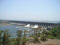 Panoramic view of Ujjani or Bhima Dam
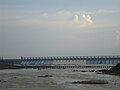 Tungabhadra Dam near Hosapete
 Krishna close to its origin at Menawali, near Wai, Satara district, Maharashtra.18th century, Maratha statesman, Nana Fadnavis built the Ghat and a palace here. This location has been used in many Hindi movies.[citation needed]


See also
- List of rivers of India
- Godavari River
- Krishna Water Disputes Tribunal
- Upper Krishna Project
- Krishna Pushkaralu
- Sacred waters
- Other rivers originating at Mahabaleshwar (Panchganga) Gayatri River, Koyna River, Savitri River and Venna River
References
External links
Wikiwand - on
Seamless Wikipedia browsing. On steroids.
Remove ads